• Skip to primary navigation
  • Skip to main content
  • Skip to primary sidebar
  • Skip to footer
Old Design Shop Blog
  • Home
  • About
    • Disclosure
    • Terms
    • Privacy Policy
  • Contact
  • Gallery
    • Advertising
    • Animals
    • Alphas and Monograms
    • Baby
    • Birds
    • Birthday
    • Black and White
    • Botanical
    • Butterflies and Insects
    • Children
    • Christmas
    • Dictionary
    • Digital Collage Sheet
    • Easter
    • Ephemera
    • Fashion
    • Flowers
    • Food and Drink
    • Frames and Ornamental
    • French
    • Garden
    • Greeting Cards
    • Halloween
    • House and Home
    • Labels
    • Maps
    • Men
    • Music
    • Objects
    • Poetry
    • Postcards
    • School Office Library
    • Sewing
    • Silhouettes
    • Sports and Outdoors
    • St Patrick's Day
    • Storybook
    • Textures
    • Thanksgiving
    • The Sea
    • Trade Cards
    • Transportation
    • Valentines
    • Wedding
    • Women
You are here: Home / Gallery / Map of England and Wales ~ Free Vintage Image

Map of England and Wales ~ Free Vintage Image

August 21, 2014 5 Comments

Here is a wonderful vintage C. S. Hammond map of England and Wales. I scanned it from a dictionary in my collection that was published in 1906. England and Wales map, vintage map download, antique map, C. S. Hammond, history geography England Wales
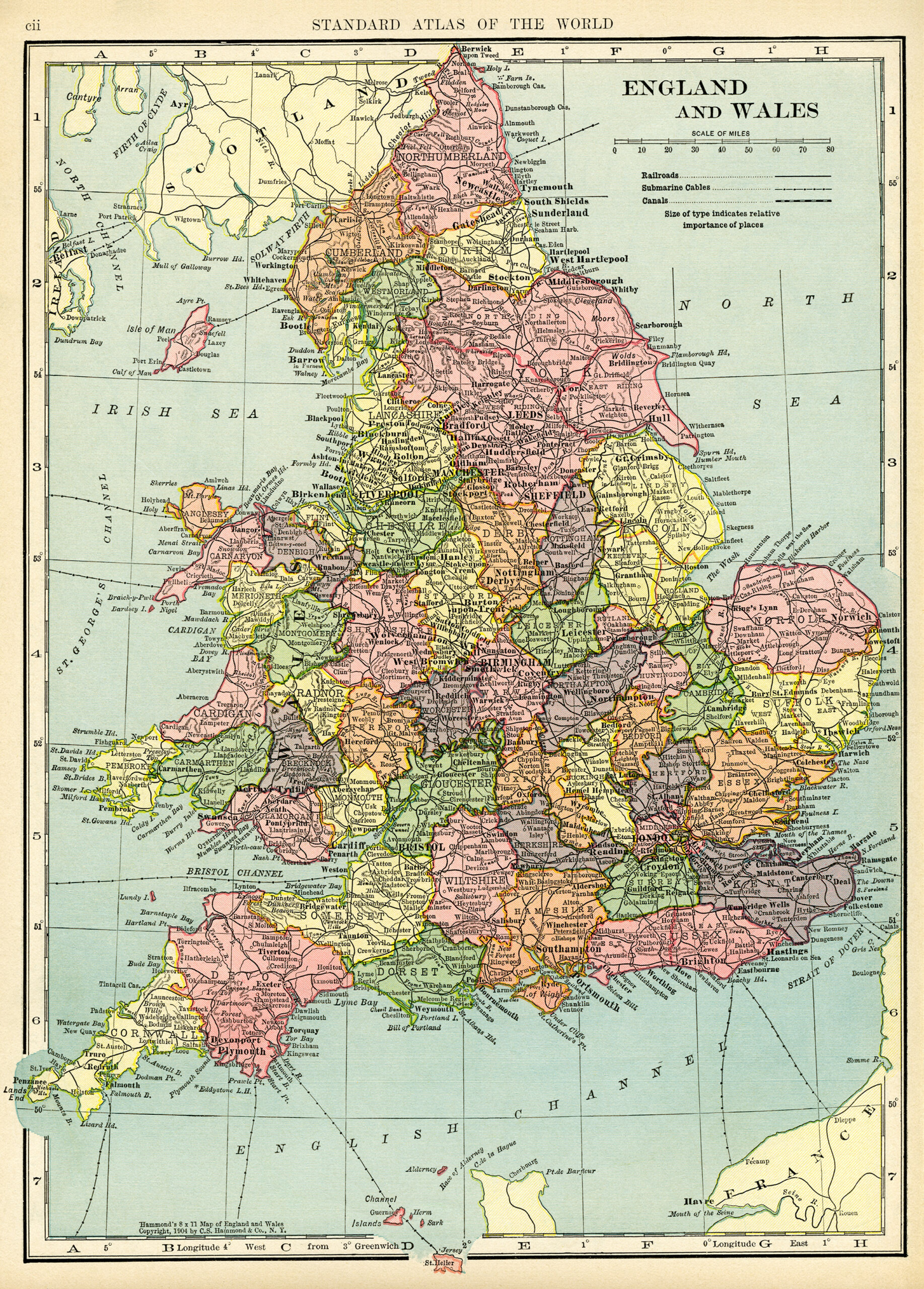
Click on image to enlarge.

Related posts:

antique map, C. S. Hammond map, history geography Germany, old map free graphics, vintage map GermanyHistorical Map of Germany ~ Free Vintage Image North and South Polar regions, vintage map download, antique map, C. S. Hammond, north pole map, south pole mapNorth and South Polar Regions ~ Free Vintage Image C. S. Hammond map, antique map, New York City map, history geography new York, free vintage mapMap of New York City ~ Free Vintage Image Oceania and Pacific map, vintage map download, antique map, C. S. Hammond, map of ocean and islandsOceania and the Pacific Vintage Map

Filed Under: Gallery, Maps Tagged With: C. S. Hammond

Previous Post: « English Mastiff Dog ~ Free Vintage Clip Art
Next Post: Vintage Sailing Ship ~ Free Clip Art »

Reader Interactions

Comments

  1. Elaine Moore

    August 21, 2014 at 1:27 pm

    Something wonderful about old maps! thanks so much

    Reply
  2. Julie J

    August 22, 2014 at 11:26 am

    You’re welcome Elaine. It’s great to know that you’re enjoying the old maps!

    Reply
  3. Tina bowes

    April 10, 2017 at 1:33 am

    Thank you very much foe maps . Looking foe area where family was.

    Reply
    • Julie J

      April 25, 2017 at 6:32 pm

      You’re welcome Tina. I’m happy to know you like the maps and I hope you will find the area your family was from.

      Reply
  4. Kari Ransom

    June 8, 2017 at 3:08 pm

    approx what size can this be printed out at with good clarity? larger than 8.5×11??

    Reply

Leave a Reply Cancel reply

Your email address will not be published. Required fields are marked *

Primary Sidebar

My Etsy Shop

​

Older Posts...

Follow Me on Pinterest
Follow @OldDesignShop

Footer

Julie is a vintage enthusiast and a Photoshop addict who collects old books and new recipes.

Contact her at: theolddesignshop(at) gmail(dot)com

More About Julie…

  • Instagram
  • Pinterest

olddesignshop.com is a participant in the Amazon Services LLC Associates Program, an affiliate advertising program designed to provide a means for sites to earn advertising fees by advertising and linking to amazon.com.

pink rose vintage postcard
vintage bicycle clip art
the first ford clip art illustration
bill of lading tag
floral cluster clip art
printable reference book page
  • Home
  • Contact
  • About
  • Disclosure
  • Terms of Use
  • Privacy Policy
  • Gallery

All content copyright © 2012 · The Old Design Shop · Website built by Maof Dvora